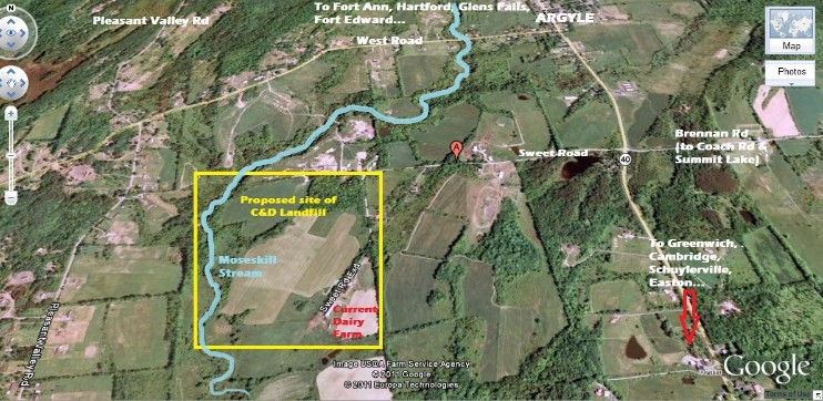
The proposed landfill site is at the end of Sweet Road in Argyle, NYThe
dump has been proposed for the end of Sweet Road in Argyle on a parcel
of land of over 100 acres. This land is currently leased as an active
dairy farm and is surrounded by over 20 residences and farmland. (see map below) This
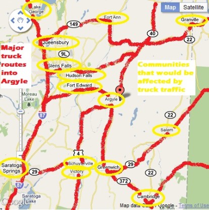
project would affect everyone in Argyle and the surrounding towns as
waste is trucked on the routes through Easton, Greenwich, Cambridge,
Schuylerville, Saratoga Springs, Fort Edward, South Glens Falls, Glens
Falls, Granville, Lake George and other surrounding towns.
- The Moseskill, which runs through the parcel is in a "Zone A" Floodplain (high-risk area)
 |
||||
We assume since Washington County does not produce a large amount, that C&D would be brought in from urban areas, NYC, Western NY, possibly as far away as Connecticut. Trucks would travel multiple roads to reach this dump; highways, local routes, back roads and quiet dirt roads like Sweet Road, past where you live - creating traffic, pollution, litter, hazards to the safety of pedestrians, school children and buses. This is NOT JUST A SWEET ROAD PROBLEM! |
 |
|||
![Sweet Road Flood Zone Map[1].pdf](classes/components/File/resources/images/pdf.png)